From 14. March to 25. March 2018 two researchers from the Institute of Optical Sensor Systems at the German Aerospace Agency (DLR) were hosted by NIC in Northland to work on a joint road safety research project.
See NZ Herald/ Northern Advocate Article on the research visit.
After presenting at AUT Computer Vision Seminar on 25. March, Project Leader Dr. Sergey Zuev and his colleague Dr. Hongmou Zhang worked with NIC Programme Manager Martin Knoche to map selected at risks roads in Northland.
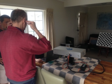
But first the very sophisticated EURO 25,000+ scientific equipment needed to be calibrated. With the help of local copy shop owner Jon, we got a very precise chess board calibration board manufactured. This was used to calibrate the high tech stereo vision camera of the Intelligent Positioning System (IPS). This process took a substantial amount of care and time.
The two cameras have a resolution of 1,000 x 1,300 pixels and the researchers showed that they could detect corrugation, rutting, potholes and other road unevenness features as a side product of their 3D mapping process. The second part of the IPS is a highly accurate Inertial Measurement Unit (IMU). It measures the x,y,z acceleration and gyro/ G-forces with 400hz (400 times per second). Both the cameras and the IMU, mimick our human eyes and balance (in our ears).

These sensors allow the IPS to locate itself within 1 cm accuracy. Given that satellite based GPS only achieves 5-10 m accuracy, this is an order of magnitude more precise.
The team mapped several sealed and unsealed roads in Northland in centimeter accurate three dimensions (3D). The roads mapped in 3D inculde: Otaika Valley Road, Town Basin of Whangarei, Marsden City and Wright Road.
In the Northland truck context this means that on the roads mapped in 3D, IPS allows to locate any vehicle to about a centimeter accuracy. In most trucks run by truck operators in Northland, this information together with the “lane keeping” technology already installed in most trucks, can assist the truck to stay within the lane detected. This will significantly decrease the amount of crashes due to truck/ trailer wheels getting off the road. The “lane keeping” technology of Daimler, Volvo and other trucks can, once it knows its exact position (GPS is not accurate enough), will then ensure that the driver gets supported to keep the vehicle on the road.
Another application is to support N3T’s Pothole Finder with visual location accuracy. On Wright Road, the researchers showed that they can not only map this complicated unsealed road in 3D but at the same time depict unevenness features like corrugation, rutting, potholes. This 3D imagery can be used by road authorities and road maintenance contractors to judge the quality and safety of these mapped roads. If this proves successful, maybe the soon commercially available IPS can be used in Northland to assist with some of these challenges and make Northland roads safer for everyone.
Once we have the research results available from Sergey & Hongmou, we will make them available for interested parties. Please get in touch with us.
Again, we thank the DLR team for their excellent work and support for safer Northland roads. We hope you enjoyed your short collaboration stay with NIC in Tai Tokerau and that this is the beginning of a longer-term research initiative with DLR and New Zealand.


